Live weather updates in the cockpit
Thales and Brussels Airlines have demonstrated a new live weather service that sends weather updates to the pilot's Electronic Flight Bag system throughout the flight. The service is a technical breakthrough — it uses the existing ACARS network despite its bandwidth limitations — and offers a host of benefits for passengers and operators alike.

For the last five years, first on the Topmet project and now on Toplink, Thales has been investigating ways to provide pilots with the latest weather data on their Electronic Flight Bag (EFB) systems. One of the objectives of these studies has been to analyse the operational benefits of a live weather function and assess the impact on flight safety, fuel economy and the passenger experience. Today, with better weather information shared more effectively among air crews, flight dispatchers and air traffic controllers, industry analysts expect the new service to translate into significant cost savings for airlines.
As part of the Toplink project, Thales and Brussels Airlines have developed and flight-tested a ground-to-air link that uses an existing communication network to send updated weather information to the pilot's EFB tablet. On 12 September 2016, during a commercial A330 flight between Brussels and Dakar, updated weather reports were successfully transmitted to pilots across the ACARS (Aircraft Communication Addressing and Reporting System) network, which is already widely used to transmit data about aircraft operations and logistics between aircraft and the ground.
The operational value of live weather reports
Pilots use weather reports during flight preparation — indeed they are required to have access to this data before the flight can take off. Regulations also require both commercial and private pilots to continue to receive a minimum number of weather parameters during the flight, in particular as they approach their destinations.
When the very latest weather data is available throughout the flight, the pilot can make the passenger experience smoother by avoiding turbulence and freezing conditions whenever possible. Landing approach profiles can be tailored to the performance characteristics of the aircraft, and changes to the flight plan can be anticipated in a timely fashion.
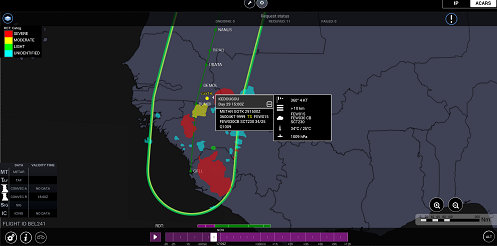
Thales's EFB weather data solution includes an intuitive user interface to display the flight plan and weather hazards such as storms, turbulence and frosting so that the pilot knows exactly where they are located as the flight progresses (4D concept).
The pilot's EFB tablet displays a weather summary for the airport and provides decision support throughout the flight, with colour coding to indicate favourable and unfavourable weather patterns.
Custom weather data requests can be set up to optimise bandwidth utilisation on the ACARS network and receive weather updates from the ground at suitable intervals throughout the flight.
Overcoming bandwidth limitations
Using ACARS for transmitting weather data is quite a technical challenge because the network is not really intended for sending large volumes of data and transmission speeds are very low (about 2 kB per minute for text). Thales worked on two fronts, filtering out any information that is not strictly relevant to the pilot, and compressing the data at the same time.
As a result, the pilot's EFB displays a complete, updated weather situation including METAR/TAF (aerodrome routine meteorological report / Terminal Aerodrome Forecast), SIGnificant METeorological Information (SIGMET) and RDTs (Rapidly Developing Thunderstorms) in the proximity of the flight path.
 |
This ability to transmit data over the ACARS network between an EFB and systems on the ground opens up new possibilities for the TopWings product line. As well as providing the pilot with a strategic flight planning capability, in-flight weather updates expand the functionality of a whole range of surveillance products, with early warning functions correlated to the mission in hand and the ability to use the data for other mission optimisation functions.
With better weather information shared more effectively among air crews, flight dispatchers and air traffic controllers, industry analysts expect significant cost savings for airlines.
Stay connected with us...
Find us on Twitter @ThalesAerospace, on our official Youtube channel Thales Aerospace and on LinkedIn Thales Aerospace.


